What is Ground Sampling Distance? And why does it matter?
Ground Sampling Distance, or GSD, is a way of measuring the resolution of survey images. In short, it tells us the distance between pixel centres on the ground in an aerial image, typically measured in cm/px. The smaller the GSD, the higher the spatial resolution, resulting in more detailed and accurate data capture.
Imagine our drone hovering above the survey area. The GSD is the distance on the ground that each pixel in the image represents. In simplest terms, a smaller GSD means that the camera is capturing a smaller ground areas with greater detail.

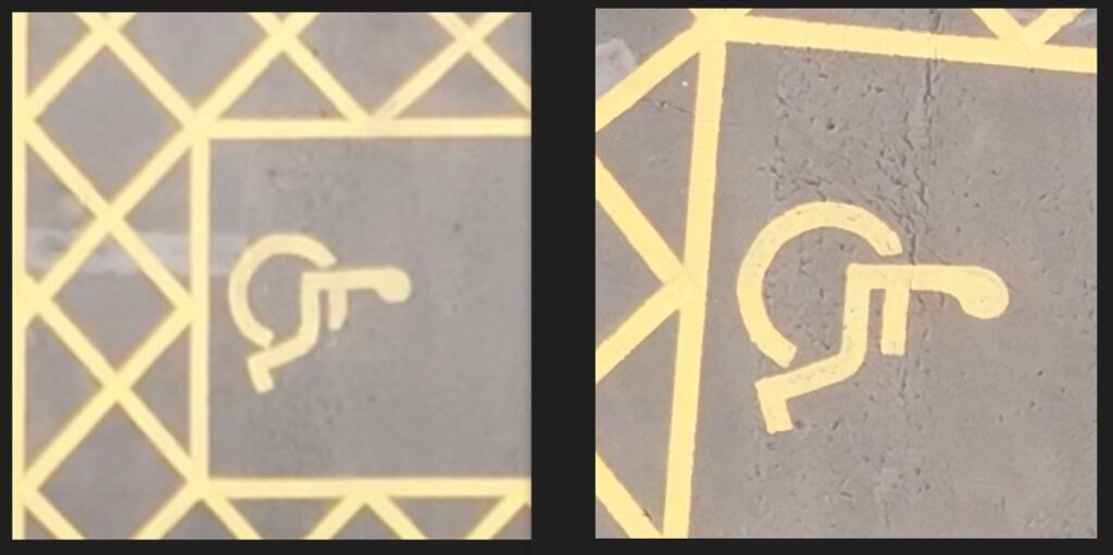
Survey image captured at different GSD levels (and different heights)
Why do we care?
GSD does two things for us. And they are related.
Firstly, the GSD value controls the detail of the imagery. Here are two images from one of our surveys. One has a GSD of 8mm/px, and the other one is around 2cm/px. The difference in detail is obvious. If we’re trying to pick out a fine detail and the GSD is too high, it just won’t be possible.
Secondly, there is a defined relationship between the GSD and the potential precision of our survey. Precision (not to be confused with ‘accuracy’) is a measure of how refined our final measurements can be. For example. if we need to measure a detail within 10mm of it’s actual size, then that clearly won’t be possible with a Ground Sampling Distance of 20mm/px (we’ll be trying to measure within a blur!) .
A useful rule of thumb is that our final precision is unlikely to be any better than roughly three times our GSD. So, if we need precision of 30mm a GSD of 10mm/px will be a good target.
How do we predict the GSD?
Fortunately, predicting the GSD is relatively simple. Our variables are:
- Flight height (the higher the drone, the larger the GSD)
- Camera sensor (the tighter the pixels are packed into the sensor, the lower the GSD)
- Focal length (wider lenses give us larger GSD)
In the end, it comes down to some straightforward maths. At Leaping Wing, we have developed our own tool to calculate the GSD for all the common combinations of drone, camera and lens. We input the desired flight height and technical specifications, and the tool does all the hard work.
Why smaller isn’t always better
As any aerial surveyor will tell you, the client’s answer to ‘what resolution would you like’ is almost invariably ‘as high as possible.’ But the lowest Ground Sampling Distance (i.e. highest resolution) is not necessarily the best plan.
The downside of a lower Ground Sampling Distance is primarily the data burden it brings. Our equipment is capable of capturing Ground Sampling Distance as low as 2mm/px, but do we really need to capture five times the data of a 1cm/px survey? In most case, no. Capturing needlessly low Ground Sampling Distance gives us headaches both for storage and processing, as all those pixels will take a lot of number crunching further into the survey process.
Plus, remember that our survey needs some real-world positioning. That’s where ground control comes in, the subject of our next post. If we can’t control our survey to the precision of our Ground Sampling Distance, then that extra data is generally not much use.
But, more on ground control next time!

